Coastline
between
Queenscliff and
Kirk Point,
Avalon
|
The
Cut,
QUEENSCLIFF
|
North-west
coast
of Swan Island (National Estate site),
QUEENSCLIFF
|

Island in Stingaree Bight on Swan
Island
|
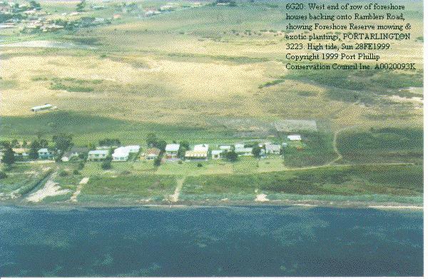
Strip development intrudes into large
area of remnant open space foreshore. Foreshore between
row of houses and the sea is mown, and is planted with
exotic plants at Ramblers Road, PORTARLINGTON
|
Extensive
remnant
coastal open space just west of Point Richards
and
Ramblers
Road,
PORTARLINGTON
|
The
bizarre ending to a road at
Beacon
Reserve,
CLIFTON
SPRINGS
|
 Exotic plantings, garden walls, gazebo, light pole,
jetties, lawn, trees felled since November 1998 on
public foreshore at 40 Avila Avenue, CURLEWIS
Exotic plantings, garden walls, gazebo, light pole,
jetties, lawn, trees felled since November 1998 on
public foreshore at 40 Avila Avenue, CURLEWIS
|
 Coast at Grand Scenic Drive (bayfill land merging
with private land), LEOPOLD
Coast at Grand Scenic Drive (bayfill land merging
with private land), LEOPOLD
|
Mariculture
works
obtrusively unscreened & too close to Foreshore
Reserve, long inlet & outlet pipes visible on
seabed, fence close to high tide mark, just east of
Seabrae, LEOPOLD
|
Northern
tip
of Point Henry:
unregulated
car
parking ruining vegetation and eroding soil,
POINT
HENRY
|
Limeburners
Bay:
large setback free of structures for almost entire
shore, HOVELL PARK |
|
|
Intrusive
aquaculture
infrastructure
just
east of Point Lillias,
AVALON
|
Point
Wilson, and its
hinterland, part of a Ramsar and National Estate
site, AVALON
|
| Point
Wilson
jetty, in a Ramsar and National Estate site, AVALON |
The
Spit, south end
(between
Point Wilson and Kirk Point)
Ramsar
and National Estate site, AVALON
|

Kirk Point: unregulated
car
parking extending to edge of beach, AVALON
|
|
|
|